The Global South has fewer weather observations.

Every orange point is a weather station, and that unevenness propagates into every downstream forecast.

01
The Data Gap

Models are trained on what we measure.

Global numerical weather prediction rests on two inputs: the governing physics, and a worldwide network of surface, ocean, and satellite observations. The physics is shared. The observations are not. Across much of the Indian subcontinent, sub-Saharan Africa, and Latin America, the same models ingest only a fraction of the measurements available over North America or Western Europe, and that unevenness of input is inherited, unchanged, by every downstream forecast.
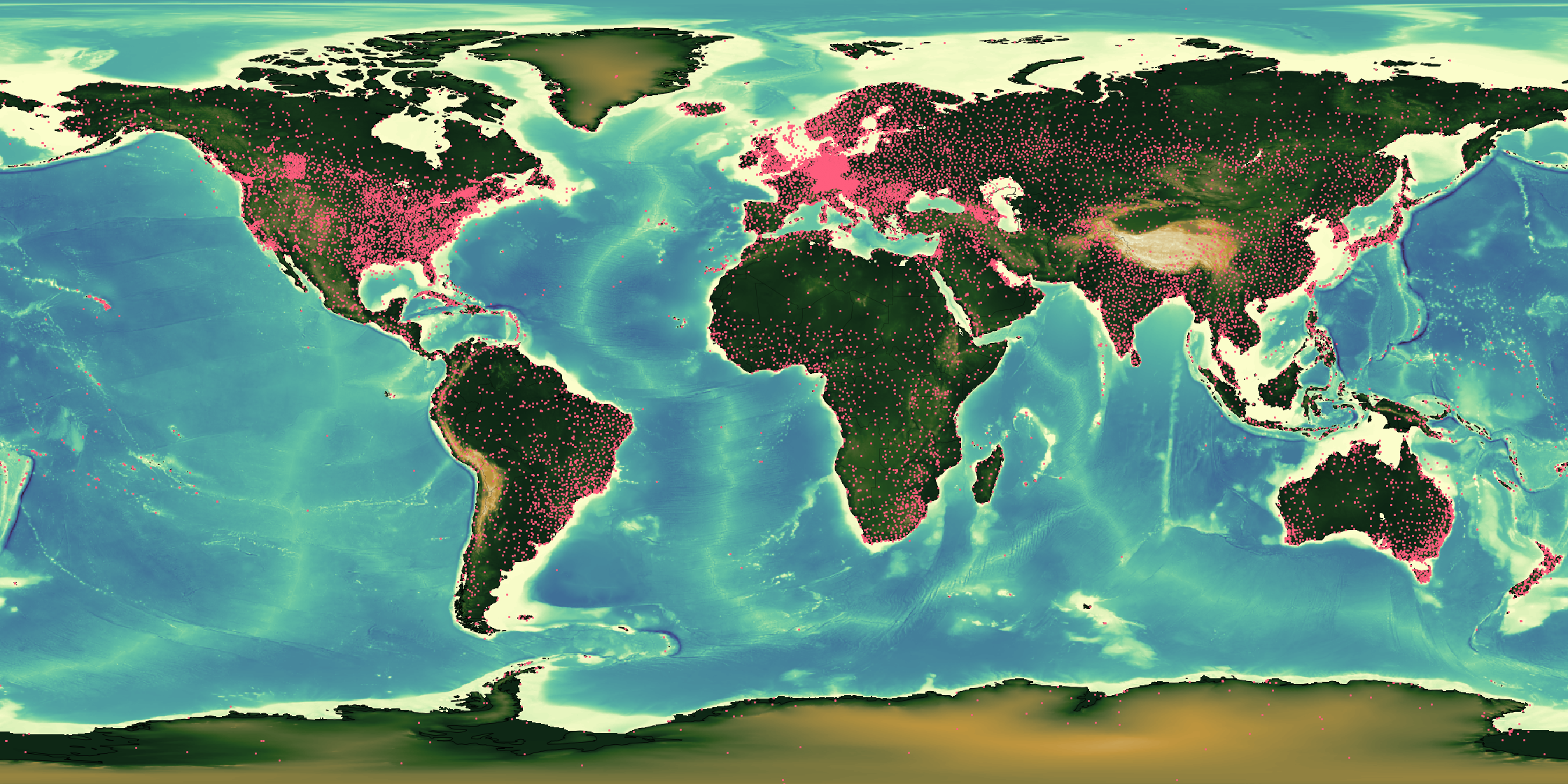
Global surface-station density over topography
Fig. 01 · Surface stations over global orography. Each pink dot marks a surface weather station.
1:14
Africa vs. Europe
Surface-station density across sub-Saharan Africa is roughly 1/14th of Western Europe's, per unit land area.
~80%
Of Tropical Oceans
Lie outside the reach of dense in-situ observation: the same ocean basins that seed monsoons and cyclones.
24h
Reporting Delay
Median latency between a station measurement and ingestion into global assimilation pipelines.
02
How We Close It

A model that learns from sparsity.

Indus combines neural data assimilation with a generative diffusion core, trained directly on decades of reanalysis and satellite retrievals. Rather than averaging missing observations into uncertainty, the model learns the structure of the gap itself and projects it forward in probabilistic space.
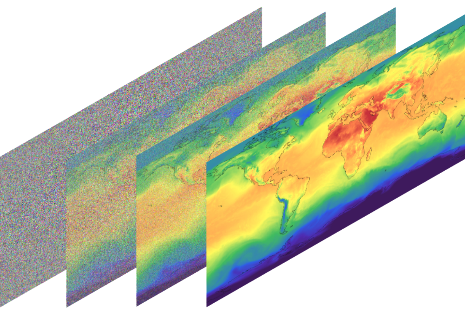
Diffusion denoising of a global temperature field
Fig. 02 · Diffusion denoising of a 2-meter temperature field. The model starts with noisy weather data and learns to recover a coherent forecast.
2km
Native Resolution
Regional fields downscaled end-to-end by diffusion, no post-hoc statistical correction.
50
Ensemble Members
Calibrated probabilistic output for every variable, every lead hour, every grid cell.
72h
Lead Horizon
Monsoon onset, cyclone landfall, grid-load peaks, priced and planned three days ahead.
03
Multimodal Assimilation

Every signal the atmosphere leaves behind.

Satellites, radar sweeps, radiosondes, aircraft reports, IoT weather stations, reanalysis priors. Each modality sees the atmosphere through a different, incomplete lens. Indus assimilates them jointly inside the diffusion core, so every observation refines the same underlying state estimate rather than being averaged into an ensemble after the fact.

50 km 20 km TROPOPAUSE 2 km SURFACE STRATOSPHERE TROPOSPHERE BOUNDARY · PBL SURFACE · 0 m x̂(t) state estimate ◦ 01 Satellite IR · MW · GEO · LEO ◦ 02 Radar Doppler · dual-pol · X / C / S ◦ 03 Radiosonde Vertical profile · 2×/day ◦ 04 Aircraft · AMDAR In-situ wind, T, humidity ◦ 05 Station · IoT INDUS mesh · 5 000 sites by ’27 ◦ 06 Reanalysis prior ERA5 · IFS · learned climatology FIG · 03 · ASSIMILATION TOPOLOGY · T = t₀
Fig. 03 · Satellite, radar, radiosonde, aircraft, station, and reanalysis signals are combined into one estimate of the atmosphere.
6×
Observation Channels
Satellite, radar, sonde, aircraft, station and reanalysis, each with its own learned error model.
109
Observations Per Day
Every pixel, pulse and pressure reading flows into the same joint posterior, no hand-tuned weighting.
~8s
Joint Assimilation Step
A single diffusion sweep fuses all channels and returns a coherent, calibrated atmospheric state.